Baildon Conservation Areas
Baildon has quite a bit of history and Bradford Council has designated several areas as Conservation Areas. Each area has now had an Assessment and then a later Appraisal. Further Appraisals will be done over time.
In the United Kingdom, the term conservation area nearly always applies to an area (usually urban or the core of a village) considered worthy of preservation or enhancement because of its special architectural or historic interest.
To quote Bradford Councils web page:-
A conservation area is an ‘area of special architectural or historic interest the character or appearance of which is desirable to preserve or enhance’ (Section 69 of the Planning (Listed Buildings and Conservation Areas) Act 1990).
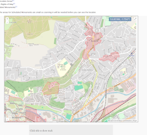
Interactive Map
Conservation Area documents.
These were previously linked to the documents on the Bradford Council website but a reorganisation of their site broke all the links. Therefore all the documents are now available from the Wiki. As and when further Appraisals are done they can be made available from here too. If you find that some are on the Bradford Council website please let me know.
- Baildon & Station Road Conservation Area Assessment. December 2005 - PDF
- Baildon Conservation Area Appraisal December 2009 - PDF
- Baildon Conservation Area Approved Map December 2005 - PDF
- Baildon Green Conservation Area Assessment December 2009 - PDF
- Baildon Station Road Conservation Area Appraisal September 2009 - PDF
- Baildon Station Road Conservation Area Approved Map December 2005 - PDF
- Esholt Conservation Area Approved Map November 2003 - PDF
- Esholt Conservation Area Appraisal January 2006 - PDF
- Esholt Conservation Area Assessment June 2002 - PDF